
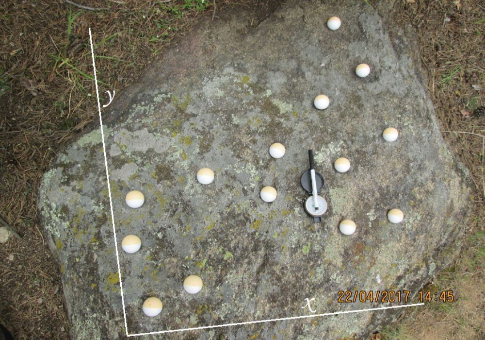
The cup-marked stone on the hill of the Staré Vinice near the village of Hnanice, in height above the sea of 340 m, is a flat stone made of light biotite granite measuring 1 x 1 m with 14 flat cups with a diameter of 5 to 8 cm, approx. 1–3 cm deep. Here the author first described and located it (Puschnik 2013, 7-8) 48°48´30´´N 15°59´34´´E. To make the cups visible and oriented to the cardinal points, the cups were filled with plastic balls and a compass because the moss layer that became part of the surface layer of the stone somewhere erased the boundaries of the cups. The author assumed that the NS direction as a projection of the meridian on the earth’s surface has been known since prehistoric times and used here since the beginning. The stone was photographed and the marks (in tab. column k and l) converted into a practical model: on the x-axis is their position as the assumed dawns of M. concerning the geographical sides in 2-day intervals in the range NE – SW = 60°–210°. The vertical distance of the cups from the x-axis was considered a measure of the moonlight (this is how the creators probably understood it). The highest one at the northeastern edge (as a possible full moon) got 100%, the lowest at the SW edge was only 3% (in the table in column l). In the next step, the practical model thus obtained was compared with the values of the
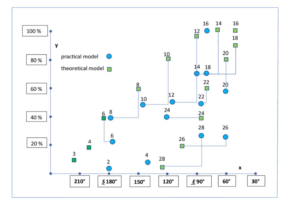
dawns and luminosity of the M. theoretical model in the combined graph (Figure 3). There is an evident similarity, which supports the conclusion that the cup-marked stone is a real illustration of the lunar cycle.
Practical model
The practical model is empirical, where the individual displayed cups are assigned the coordinates of the moonrise (on the x-axis) and luminosity (on the y-axis) as a % of the moonlight from the full moon. The luminosity of the full moon (100%) was assigned to the highest cup at the NE edge. All points in the graph thus represent ad hoc associated values (geographical positions of the Moon ascent after dark + its luminosity) and allow to compare both models in linear form. In the practical model, in the first half of the M. cycle (6, 8, 10, 12, 14 nights), the dawns are located further south and less light, around the full moon it is possible to agree with the theoretical model, in the end of the M. cycle the dawns are “more eastern” than in theory. It can be assumed that during the construction, the NS axis was deflected NW by 15 ° and directed from NNE to SSW. This methodology was also used to analyse the Heiliger Stein and Nebra disc, where the cups and targets were replaced by icons for the nights of the lunar phase to get better clarity.
Frequently used abbreviations in the text: M. = Moon, S. = Sun, NS north–south, FBC = funnel beaker culture, tab. = Table, if distances or coordinates are given, they were provided by the application mapy.cz, terms night – day are used promiscuously for a 24-hour interval, time record is in CET (UTC + 1 hour).
Heiliger Stein
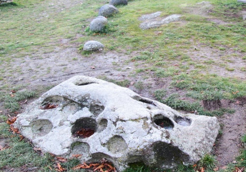
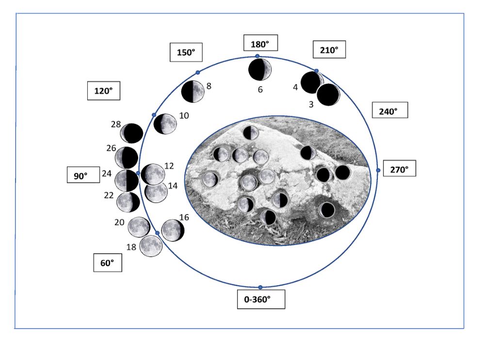
The second cup-marked stone, known from modern history as pilgrimage location of (Wikipedia, “Heiliger Stein (Mitterretzbach)”)topographically 48°47´29,8´´N 15°58´15,1´´E is made of light biotite granite belonging to the Dyje massif, which extends up to Austria. It is located on the Austrian side of the border with the Czech Republic near the village Mitterretzbach; on the Czech side is the closest village Hnanice. It can be described as a round, 1 m wide and 2 m long triangular shape with a base in the ground, with the sides inclined to the west and the east with 14 cups. The upper edge is oriented to the southeast and the crucial feature is its cup decoration in the eastern area. Here are 8 complete cups; the last two on the lower NE edge are half immersed in the ground. Predominantly slightly oval with a 20 – 25 cm diameter arranged in three levels could represent a reduced graphic record of the 28-night lunar cycle. The image of the stone was inserted into a circular theoretical graph of the M. cycle and the cups were filled with icons of model M. phases in 2-day intervals (Figure 5.b) On the west side, the cups are occupied for 3, 4, 6 nights, when M. sets shortly after dark, the eighth night is recorded on the southern edge. Then M. ascends to the meridian for the first time and then every night. On the eastern side part, the cups are arranged in rows (3 + 3 + 2) x 2 as 16 light nights from the 10th night of the M. cycle; the last 2 cups are half-immersed in the soil at the NE edge when the M. rises around the morning time. There is an evident match with the dawns and luminosity of Moon and the arrangement of the cups. As with the Staré Vinice location, it is possible to consider the Eneolithic record of the Moon cycle concerning the well-archaeologically documented presence of the funnel beaker culture (FBC).
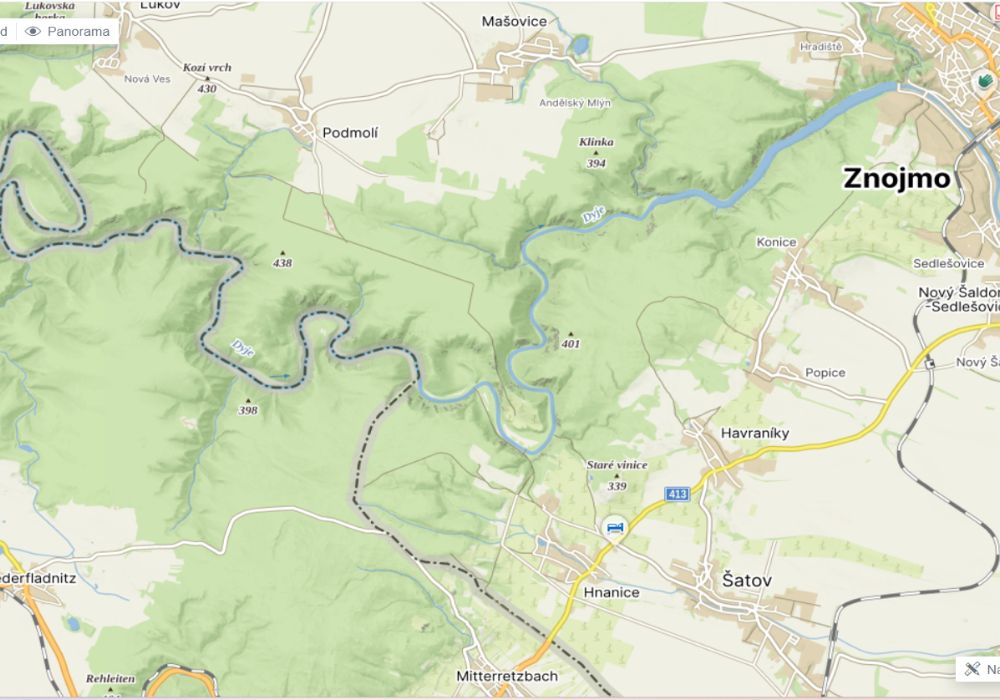
Map legend 1. Staré vinice 2. Heiliger Stein 3. Šobes/Hnanice IV 4. Hnanice VII 5. Znojmo 6. Mašovice
Archaeological excursion to the Eneolithic
Both cup-marked stones are located in an area inhabited in the older Eneolithic, documented by a number of archaeological finds. At a distance of 4 km from the Staré Vinice, on the other side of the state border is another cup-marked stone Heiliger Stein/Mitterretzbach/Austria and 2.5 km from it is the Eneolithic locality Hnanice VII. Kovárník (2002) reports in analytical thesis, in addition to his own finding unit from Hnanice VII (FBC votum in a storage pit and fragments with a striated incision), also about other settlements (Kovárník 45-50): Hnanice IV on the right bank of the Dyje opposite the Šobes housing estate (Lukov II) according to him, citation: ‘The grouping of Eneolithic forts on the Dyje suggests that an important old trail ran through its canyon-like valley from the lower Podyjí, the Podpálava area, or the lower Pomoraví area from the confluence of the Dyje and Moravia to the hilly inland’… A slightly more distant FBC location, including ceramics decorated with a striated incision, was on the Znojmo castle hill – the distance of Staré Vinice – Znojmo via Konice, Popice is 7.7 km (Podborský 1988). These archaeological sites of the oldest phase of the FBC are not only a regional phenomenon. Znojmo was part of a large spatial expansion of the FBC. Ruttkay and Pucher (2006) and Šmíd (2017) describes the territorial group of the oldest phase of the FBC, crossing the borders of Moravia in the north of Lower Austria as the Baalberg group of the FBC with ceramics decorated with a striated incision (Furchenstich) and the Retz type as its classical representative. The whole culture dates back to the period from the 40th to the 38th century BC, the Retz type then to the period of the 38th century BC with a duration of approx. 100 years. To the south, this epilengyel culture of the mixed FBC group with striated incision ceramics is widespread in southwestern Slovakia, Lower Austria, Burgenland and the Hungarian Transdanubia(Čambal et al. 2011)